The Legend of Jim Charles (and the search for Jim Charles Rock)
March 2, 2009
There are many versions of the story of Jim Charles, like any good story that has been told around campfires for many generations. A great version of the story appears in Mike Parker’s book, “Wood Chips and Beans” and another good version comes from a blog by “the nature writer”, Laurie Lacey. Basically the story goes like this:
Jim Charles was a man who lived in the Kejimikujik area in the 1800’s. He was one of the most skilled of the guides in those woods and frequently took sporting fishermen and hunters deep into the woods where the fishing and game hunting were prime. He and his wife lived on what is now known as Jim Charles Point on the Kejimikujik Lake. Jim had discovered a gold mine deep in what is now the Tobeatic wilderness and became quite rich. Now the men in the village became jealous of Jim Charles’ fortune and tried to get information about the location of this gold mine which he kept a secret. One night a man became quite forceful with Jim at a bar when he refused to give up the location and picked a fight with him. Jim knocked the man clean off his feet and several hours later, the man was dead.
It should be mentioned now that Jim Charles was a Mi’kmaq man and though he was well respected within the community, there was no guarantee of a fair trial with the murder of a white man hanging over his head. So Jim did the only thing he knew to do and took to the woods.
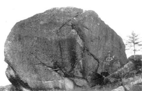
Photo Courtesy of Nova Scotia Archives and Records Management
Reference Number: N-2516/ Album 43, #2
Author’s Note: It is mentioned in other online sources that this is Boundary Rock. It is not. This is what I believe is Jim Charles’ Rock. Boundary Rock is much smaller than this rock as is apparent from the size of the man standing in the bottom right hand corner of the photo. It is believed that this photo was taken by J.A. Irvine in 1899.
It is said that Jim Charles stayed in those woods for years. He stayed in there for fear that the men of the village were looking for him. He hid under a enormous rock, where there was a cave underneath, and from on top of which he could see anyone coming from miles around. This is what’s now referred to as Jim Charles’ Rock. It is said that it is near Cofan Camp on the Sand Beach Lake, but like the Boundary Rock, little is know as to its whereabouts. He also never returned to his gold mine, for fear that the ghost of the man he killed was haunting it. Also, he had no need for gold unless he could spend it, which would require him returning to town.
Some of the stories about Jim Charles claim that he did in fact return to town and stood trial and was found not guilty for the murder of the man. Some say he never returned from the wilderness. Whichever is true, the fact is that the exact location of the mine, and the rock died with Jim Charles.
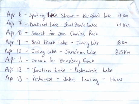
So we will spend a day on our trip to search for Jim Charles’ Rock. Here is a draft of our itinerary as it stands now:

trip itinerary - The Search for Boundary Rock

The Tobeatic Map is good to see. It shows all your portages (carries). Wish you luck in finding the rocks. Interesting stories of Jim Charles, eh! If you find Boundary Rock perhaps you’ll find that the Easter bunny got there first. Guess you’ll have to plan your itinerary and present that when you get your permit to enter the Tobeatic.
Have fun!
Dad
interesting venture, the symbol by the date means “holy”, i hope you publish the gps position so we all can enjoy it.
thanks raymond
interesting venture, hoping you find it. please publish the gps cordinates.
the symbol by the date means”holy”.
good luck
raymond